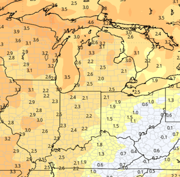



Our Beacon Credit Union Harvest Weather Forecast is segmented over the next two weeks across Indiana. We are looking at a dry start, with no precipitation in the near term from the weekend through midweek. We then shift into a very wet pattern from Wednesday through next Monday. We follow that up with another round of dry weather for the balance of the week of October 5, and we are hopeful that pattern can extend into the following week. Let’s break it down.
Mostly sunny skies will dominate from Saturday through Tuesday. We should see temperatures slowly climbing, but not reaching exceptionally warm levels. Still, we expect normal to slightly above-normal temperatures through Tuesday afternoon. Good evaporation rates and rapid drying should be the hallmark of this period. However, fieldwork will likely be limited by cool mornings and heavy dews that will not burn off until mid- to late morning. This is typical late September and October weather.
While we experience nice weather here in the near term, there is plenty of activity happening to our west. Over the weekend and into early next week, plentiful moisture will move out of the Great Plains into the central and western Corn Belt but will run out of gas before reaching either Michigan or Indiana. That “fizzling” of moisture will end late Tuesday.

The remnants of Hurricane Polo, which has battered the western coast of Mexico over the past few days, are tracking across the southwestern U.S. and into the Plains before eventually beginning to move eastward by midweek.
The first round of moisture moving into Indiana and Michigan will arrive Wednesday. This will act similarly to a warm front, streaking eastward as the main body of the system remains back in the Central Plains.
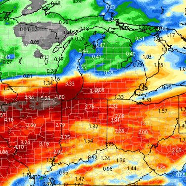
Still, we expect rainfall totals of 0.25 to 1 inch Wednesday into early Thursday in Indiana and probably 0.25 to 0.75 inch in Michigan, concentrated in the southern half of the Lower Peninsula.
After a brief break Thursday afternoon, we expect secondary rounds of precipitation to move through Friday, Saturday, and Sunday, finally tapering off Monday morning to midday. Those surges will come as the main low-pressure system finally exits, moving from the Central Plains to the northern Great Lakes.
Moderate to heavy rainfall will move across the entirety of the Eastern Corn Belt. The biggest totals are expected in Illinois, Indiana, and Ohio, while Michigan will see a north-versus-south divide. Although we expect rainfall across all of Michigan, totals will be significantly lighter than those expected in the “I” states.
Over the combined duration of this wet period, from Wednesday through Monday, forecast rainfall totals range from 0.5 to 3.5 inches, with 100% coverage across Indiana and 80% coverage in Michigan. The map below shows the weather setup for the region.
After lingering moisture diminishes and moves out on Monday, we should transition into a drier forecast pattern from Tuesday, October 6, through the rest of the week, with a likely dry extended forecast window as well.
Extended Period:
The extended period is mostly dry. We expect decent sunshine to continue from October 9-12, with an upper-level ridge holding over a large part of the nation’s midsection.
One thing we can say is that the extended period will be cooler, thanks to a significantly different air mass dominating the region. This cooler air will initially arrive behind the strong storm complex mentioned above for later this week, and it will likely persist throughout the extended period as drier weather emerges.
Again, we are not looking at anything dramatically below normal, just a reminder of the season we are in. October usually sees a nice drawdown in temperatures.
Weeks 3 & 4:
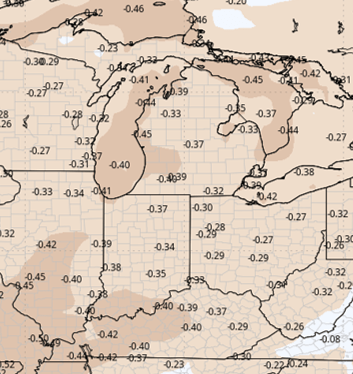
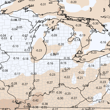
Week 3 is expected to be well below normal in terms of precipitation. Week 4 returns closer to normal, but with a continued dry undertone.
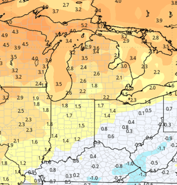
Temperatures are expected to be slightly above normal in Week 3, with stronger warmth likely in Week 4.
Week 3 Precipitation:
Week 3 Temperature:
Week 4 Precipitation:
Week 4 Temperature: